


Your Canal Connection
News & Updates
- Discovery Center and Gift Shop, Tues.- Sat. 9:30-4:30.
- Boat Tours at 11:30AM, 1:30PM, and 3:00PM.
- Canal to Cloth Tours: February 24, March 14 and 30 at 3:00PM. Purchse your tickets here.
- SAVE THE DATE! 3rd Annual Canal Discovery Day on April 20 from 10-4. FREE event!
Winter Schedule, January-March:
Share the Love on Augusta Canal/ Gerald Jones Subaru
The Excursion with David Zelki
Explore
the Augusta Canal. Whether you hike, bike, paddle, or just float through Augusta Canal’s history on a guided boat tour, we invite you to explore our recreation and outdoor experiences along miles of towpath, trail and canal waters.
The Augusta Canal weaves threads of history, scenery, and recreation into a delightful tapestry as it winds its way through Augusta, Georgia.
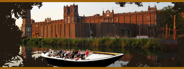
Hike or bike on the towpath edging the historic canal, which takes you past natural and urban landscapes, giving glimpses of wildlife, offering beautiful scenery, and surrounding you with nature and history. Fish from the canal banks, paddle a canoe or kayak in the gently moving waters, take one of several daily guided boat tours aboard a replica canal cargo boat, or kick back and relax on an evening Music Cruise.
Explore the nation's only industrial power canal still in use for its original purpose. Visit the Augusta Canal Discovery Center at Enterprise Mill to hear the stories of the people who built the canal in 1845 to harness the water and power of the Savannah River, and learn about the progress, problems and promise of its 170-year history.
Discovery Center and administrative offices located at 1450 Greene Street, Augusta, GA
30901
706-823-0440

Augusta Canal - Georgia's first National Heritage Area.
A partner of the National Park Service and a member of the Alliance of National Heritage Areas. An official “Passport to Your National Parks” stamp cancellation site.